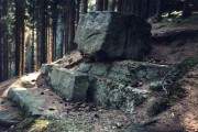
The legendary "Teufelstein"
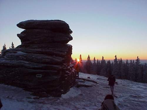
The legendary "Teufelstein" (Devil's Rock or Lucifer's Rock) is a conspicuous rock on the top of the highest hill (1498m) in the Fischbacher Alps Northeast of Schanz near Fischbach, Styria/Austria.
Coordinates of Lucifer's Rock:
y -53.715.0 / x + 5.258.755.0 or 47°27' North/15°37,5' East.
Location
The central line of the total solar eclipse of August 11th, 1999 went directly over this monument.
In recent times, this rock became the subject of various speculations, theses, and serious scientific experts’ reports following the discoveries of the lawyer and local historian, Dr. Hubert Stolla of Kindberg.
There are several facts, that lead to further considerations:
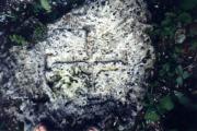
* Two walls of Devil’ s Rock seem to be not naturally broken (geological expertise, Univ. Prof. J. G. Haditsch, Leoben). The walls seem to be artificially treated in a way to make a flat surface.
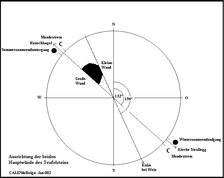
* One of the hands on the flat vertical wall point to a spot on the horizon where at the winter solstice, the morning sun rises, or more exactly, the place where, about every 18 years, the full moon rises on the evening of the summer solstice.
Orientation of the plain walls of Teufelstein
The Devil’s Rock, together with the legendary Königskogel (King’s hill) and four ancient churches, forms a design of Pythagorean triangles that cannot be of random origin. The design is a kind of deltoid form, with its axis exactly 23.5° Northeast, and so is in accordance with the declination of Earth's axis. Several mathematicians say that coincidence can be excluded for the origin of this design. Behind this triangular shape, there must be a plan of construction (according to German experts Gunter Bischoff, Univ. Prof. Josef Gölles, and Univ. Prof. K D Wernecke).
The geometrical alignment of ancient churches around Teufelstein
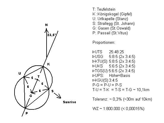
* The Devil’s Rock and two more ancient human-worked stone monuments describe a right triangle with the proportion of Golden Ratio.
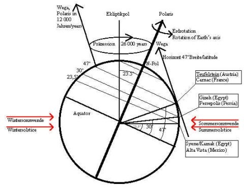
Lucifer's Rock lies on the 47° parallel, a significant position on Earth! For geodesy and astronomy significant positions of Earth:
See the significance of 47° latitude in geodesy and astronomy:
47° latitude (position of Lucifer’s Rock/Austria, or the megalithic stone rows in Carnac/ France) is the southernmost position on Earth, where during the entire circle of precession (during the whole wobble of Earth’s axis of about 25,800 years) all polar stars can be observed. Thus you can see now also Canopus (Polaris in about 12000 years)
How could have handed down and survived ancient knowledge in astronomy and geodesy?
Fantastic Vision or Fact?
A journey into catholic history helps to reconcile the facts:
Around 600 CE, Pope Gregory I, after "long and fundamental reflection," gave the following instruction to Abbot Mellitus for the missionary to the Britons:
"The ceremonial places of these people must not be destroyed, only the idols there. The places should be sprinkled with holy water and consecrated to the true God. In this way, when the location is not destroyed, the people will recognize the true God in their accustomed locations and will no more sacrifice to the devils.”
(Venerable Bede 673 - 735)
The missionary in Noricum probably carried out the same instructions as happened in Britain. With the Christian, mostly Irish missionaries, the ancient ceremonial places were made part of the Church, and so these locations are continued in use as holy (or condemned) places, even when the old places are banned. When the heathen did not quit their pagan rituals, or if building a church was not possible because of the terrain, some pagan locations were condemned or banned. In the case of the Devil’s Rock, the name and even the function is handed down in folk tradition and myth.
"After paradise, in the holy night, Lucifer the devil wanted to build a tower that reached to heaven..." says the best known myth of Devil’s Rock. The Styrian poet Peter Rossegger, who was born in 1843, told of this ladder to heaven. He called it an unfinished tower of Babylon and wanted to give lecture tours on the ancient monument.
The southern wall of the Devil’s Rock once was treated by "heavenly mechanics" in a way that it reaches to that point on horizon where, at winter solstice, on Holy Night, the sun rises. Before sunrise, however, in that same position is the morning star, whose Latin name was Lucifer, light bringer. This is nothing but the planet Venus. Lucifer and Holy Night mean the morning star and the winter solstice. The still-living myth tells us exactly about the function of the rock.
But, who, when, why, and how were the former pagan locations constructed in that geometrical formation around Lucifer’s Rock?
The question Who? cannot be answered, and we must speculate, for there have been no archaeological excavations. The parallels between this calendar monument and the megalithic cultures of the Celts, Egyptians, Mayas, and Incas are evident.
Here is a perspective on the question Why!
Often in these cultures are found stone monuments that point to where the sun rises on the horizon at solstice. The monuments plot a special point on the horizon, where the sun turns back after reaching the southern or northern extreme on its way to year and horizon. Near Lucifer’s Rock for example, the name of a famous mountain at Semmering is "Sonnwendstein", which means "solstice rock."
By observing the sunrise for long periods of time and counting the days, a calendar is born. By simultaneously observing the moon, it is possible to find the Saros cycle and predict eclipses.
Who can imagine what political and spiritual power was given to the one who had knowledge of these things in ancient times. Whoever could predict an eclipse was seen as being in contact with the heavenly powers, and such a person’s reputation was secure. The know-how first surely was subconscious, but later was handed down in a secret, cultic, religious way. The worship of gods and the profession of priests was born.
That led to the constructions of the triangles around Devil’s Rock. The simplest triangle (3:4:5) seems to show a higher possibility of abstraction.
A recent example: At end of 19th century, when the channels of Mars were discovered, the euphoria was so great that there was a serious plan to send a message to the assumed people on Mars. This would take place by building huge Pythagorean triangles in the Sahara desert. The spacecraft that left the solar orbit some years ago has a similar message on board. Did the people around Lucifer’s Rock want to contact the heavenly bodies by using Pythagorean triangles, or was it an attempt to perform some ritual upon the land for spiritual purposes? Perhaps historians of the future may enlighten us.
But how could locations be measured in such an exact way over such huge distances? The people could haved used bearing sticks and ropes and "crosswheels" for triangulation. To find an exact position now, we need like a protractor or sextant, a compass, and the exact time, much a sea captain. Did they already know about the function of the "Jacob stick" that was published in the medieval by the Jewish Rabbi Levi ben Gerson? The form of the Jacob stick can be found on many hills around Styria as the "weather cross." Perhaps the architects of the "dragon around Devil’s Rock" knew it, but the secret tradition has been lost.
The local inhabitants slowly are becoming conscious of the ancient tradition, and the local tourism officials want to revive the ancient cultural matters. Science is forced to remember long-forgotten information.
We hope that at the interdisciplinary scientific symposium about the phenomenal Devil’s Rock, experts on geodesy, astronomy, archeoastronomy, statistics, geology, archaeology, religious and ancient history, local history and geography, and mythology can discuss all points of view and reveal the mystery of ancient phenomena.
The symposium took place Aug. 6th - 7th 1999 in Jakob im Walde, Steiermark, Austria.